Redistricting: First look at proposed D & R congressional maps
Kari Chisholm
For political map nerds, yesterday was a big day. Opening bids were made by the Democrats and the Republicans engaged in the redistricting process.
In this post, I'll take a look at the proposed congressional maps.
Remember that these maps are opening bids in a negotiation, so expect them to represent their authors' greatest dreams and desires (and probably not a few bluffs and misdirections.) Also, it's entirely plausible that we'll see maps from other, outside interested parties. (Already, the DPO put out its own legislative map for folks to examine.)
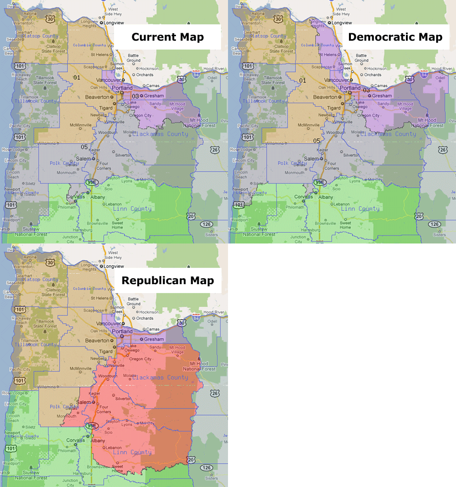
So, for starters, the big picture:
 (Click to zoom and view side-by-side.)
Apologies to folks in Central, Eastern and Southern Oregon, but this tight crop was the best way to see the detail. Central and Eastern Oregon are, of course, in Greg Walden's OR-2. Down in Josephine County, there's some variation on the way the border between OR-2 and OR-4 is drawn (but it's an area with such small population, it looks like everyone just used that area to balance population numbers between those two districts.)

As you can see, the Republican goal is to pack all of Multnomah County into Earl Blumenauer's OR-3 - thus making David Wu's OR-1 and Kurt Schrader's OR-5 a little less Democratic. Relatively, the Democrats have done more to keep things close to the way they are now in Multnomah County - with the Willamette River and Powell Boulevard dividing the three districts. Clearly, the Republican map is the radical shift here (despite their whining to the contrary.)
The way that the district map is now actually makes some good sense in terms of "communities of interest". Right now, the Dunthorpe/Riverdale area joins the Wilson H.S. part of SW Portland with Lake Oswego to the south in OR-5. The part of Southwest that's north of I-5 (Multnomah and the west hills) joins Garden Home, West Slope, and Raleigh Hills - as well as downtown and Northwest in OR-1. And the NW industrial area joins North Portland in OR-3.
Under the Democratic plan, the South Waterfront development shifts from OR-5 to OR-1 - as it should, since that area is now clearly part of the downtown milieu. And while Milwaukie makes good sense shifting into OR-5 to join Oregon City and Gladstone, the addition of Sellwood, Eastmoreland, Westmoreland, and the Reed College area to OR-5 admittedly seems a bit out of place (though it does put Reed and Lewis & Clark in the same district.)

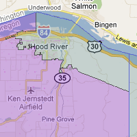
One bit of sure-fire controversy about the Democratic map is the way in which it splits Hood River county. Personally, if it were up to me, I'd have put all of Hood River into OR-3. I think Hood River has more in common culturally with the Portland metro area than it does Eastern Oregon. But that would mean putting two incumbent members of Congress in the same district, something that the courts have historically preferred to avoid.
There's much, much more to talk about on these congressional maps, but that's enough for now from me. What do you see on these maps? Where might the negotiations lead? The map PDFs from the legislature are generally a mess to work with.
Instead, I highly recommend taking a look at the the public mapping tool from Moonshadow Mobile. That's an Oregon company (Eugene City Councilor Mike Clark is a VP there) that layers a redistricting tool over the intuitive Google Maps interface. (Note that you can't edit anything there, but you can zoom in and out. Also, full disclosure: that's the company that provided redistricting tools to the Republicans, but whatever. It's a nice map tool. Oh, and "Map 1" is Democrats and "Map 2" is Republicans. Enjoy.)
Next up, I'll be digging in to the proposed legislative maps - but with 60 districts, well, there's a lot to think about. Stay tuned.
 |
More Recent Posts | |
Albert Kaufman |
|
Guest Column |
|
Kari Chisholm |
|
Kari Chisholm |
Final pre-census estimate: Oregon's getting a sixth congressional seat |
Albert Kaufman |
Polluted by Money - How corporate cash corrupted one of the greenest states in America |
Guest Column |
|
Albert Kaufman |
Our Democrat Representatives in Action - What's on your wish list? |
Kari Chisholm |
|
Guest Column |
|
Kari Chisholm |
|
connect with blueoregon


5:58 a.m.
May 12, '11
I'm always surprised the GOP doesn't try to get the McMinnville area in the 5th District.
Check out New York's 28th distrcit or Illinois Arizona's 2nd district for some oustanding (poor word choice?) use of gerrymandering.
7:18 a.m.
May 12, '11
"I think Hood River has more in common culturally with the Portland metro area than it does Eastern Oregon."
This is the part of your post I find the most intriguing since it illustrates the controversy in redistricting. As Hood River transforms to some degree, I think older residents would strongly disagree with you while the wind-surfing crowd would concur.
10:58 a.m.
May 12, '11
Minor correction in the post above: Mike Clark is the VP of Moonshadow Mobile, not its owner.
11:16 a.m.
May 12, '11
There is also an interactive map now up on the legislative redistricting website.
I'll let others more technically inclined then me decide which is most useful.
11:53 a.m.
May 12, '11
The Republican one seems to make more sense geographically. I don't know what the demographic impacts are.
12:05 p.m.
May 12, '11
You mean, it's "prettier"?
Certainly that's what Rep. Shawn Lindsay thinks matters. "Theirs looks like a Picasso, ours like a nicely patterned quilt, nice and uniform." (from the AP)
Remember that districting is about people, not acreage -- so it's about putting together communities of interest, not drawing pretty little boxes.
1:57 p.m.
May 12, '11
What, you mean the people that i apartments who live south of Powell St. in Portland are not in the same community of interest as a farmer living outside unincorporated Sweet Home?
;)
1:58 p.m.
May 12, '11
...that live in...
Mea culpa
3:30 p.m.
May 12, '11
Yeah, that it.
8:43 p.m.
May 12, '11
Sure. But the D's plan for CD3 is not terribly defensible in terms of communities of interest. There is a legitimate case to be made for tying PDX suburbs into downtown based on transportation corridors, and the fact that many suburbanites work downtown. But Hood River? Columbia County? FWIW, the IPO will be releasing a critique of both house plans next week.
9:43 p.m.
May 12, '11
Hood River makes good sense, though as I said, I'd have put the whole county in.
Columbia County has also become a bedroom community for Portland, though it probably has more in common with Hillsboro in that way.
I think there's a reasonable argument for a Columbia River district, but that would be a whole different animal.
7:10 a.m.
May 13, '11
Hood Rivers inclusion "makes good sense" based on what, exactly?
Geographic boundaries? No. Political boundaries? No. Communities of interest? No. Making it easier for a D to win in CD 5? ???
12:00 p.m.
May 13, '11
From my post: "I think Hood River has more in common culturally with the Portland metro area than it does Eastern Oregon."
1:10 p.m.
May 13, '11
Hood River has more in common culturally with the Pearl District than it does with the Dalles?
Really?
What's your argument?
12:34 a.m.
May 14, '11
Doesn't sound like you've spent much time in Hood River.
10:18 p.m.
May 12, '11
Well of course you all are going to defend the Democrat's proposal; we all know what team you carry water for. But it is clear to the unbiased observer that the Oregon House Democrats aren't even at all ashamed of twisting and bending these district lines to maximize partisan advantage. Hey it worked 10 years ago, why not try it again? As far as the Congressional lines go, continuing to bend 5th district around like a paperclip instead of the more logical and definite lines of the Republican proposal shows how it is about raw political power, not fairness. I don't expect fairness. But it would be nice to hear an honest assessment of the districts. For example the Democrats could say "We're in charge and there is nothing you can do about us basing our districts on ensuring our power. Nyah, nyah, nyah." Instead they pretend it is about "communities of interest" or how rivers and mountains aren't really geographical boundaries. We know you are exploiting your political advantage for partisan gain. Quit pretending it is otherwise. Hey you won the House and Senate, largely due to Bradbury's gerrymandering 10 years ago. Own that it is all about raw political partisanship. You can all pretend it isn't about that, but the general public isn't fooled. Man up. You won. Quit trying to pretend it is a fair process. The fix has been in for some time.
Congratulations.
12:19 a.m.
May 13, '11
Ken --
First of all, read my post. You'll note that I noted the controversy on the Democratic map. Also, I've got another post up this evening with Congressman Blumenauer's concern about the Democratic map.
Second, if Bradbury's legislative map in 2001 was a ridiculous gerrymander, how come the Democrats didn't take control until 2006?
Third, I'm going to repeat what I said above: Districts are about people, not acreage. While nice square districts would be pleasant to look at on a map, that's not what matters. What matters are communities of interest.
10:21 p.m.
May 12, '11
BTW, I am not that "unbiased observer." I admit my biases. I showed both maps to many disinterested parties at my work and the consensus was clear that the Republican Congresional maps made more sense.
11:05 a.m.
May 15, '11
And was that before or after you regaled them with your own philosophies?!
The GOP map presents its own radical biases - "Let's stuff Multnomah into a District unto itself so those radical Portlanders have less impact."
But let's just stipulate that GOP and DEM plans will respectively seem to favor their own. Nonetheless, drawing lines with special consideration for communities of interest is the paramount descriptor for redistricting... even if the lines don't perfectly conform to simple geometric shapes.
Much has been made of the "north peninsula" of the current CD 5 which stretches up into the waterfront of PDX. When I first saw the map, I too looked at it quizzically. But the Willamette River defines the business districts on or near to it, and they have like interests, whether in Lake O or PDX, so the configuration stood the test of a court.
Times change; there is growth and redevelopment, so the District lines change. But that doesn't mean that the GOP can fence off Multnomah County or that Democrats could use Portland like a wheel hub.
It's also apparently necessary to point out that when regarding the Communities of interest, that does not mean that any one district cannot include multiple communities of interest. I.E. it's ok to include a rural community in a district that also houses urban business district. The Community of interest directive simply emphasizes the need to not split an individual Community of interest.
10:27 p.m.
May 12, '11
Analyzing the proposed plans? Here's a clarification of the "communities of interest" issue, which is one of several criteria in the Oregon law. The statute says that "each district, as nearly as practicable, shall . . . not divide communities of common interest...." ORS 188.010.
There is no requirement that each district be a single community of interest or that it be made up of similar communities of interest. In fact, districts may contain several different communities of interest and be perfectly appropriate (as long as they comply with the other requirements).
12:23 a.m.
May 13, '11
Senator Bonamici, thank you for joining us here to discuss the maps.
And thank you for that clarification. Certainly, "not divide" isn't the same as "must join"
That makes logical sense, actually, once you think about it. The political clout of a particular community of interest is best maintained when it's kept intact, rather than divided - even if it is only a minority within a particular district.
11:09 a.m.
May 15, '11
Ah, I should have kept reading before I responded to Ken. You stated it so much better than I did!